


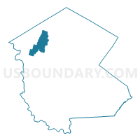
Voting District 020002, Sullivan County, New York
About
Outline

Summary
| Unique Area Identifier | 637838 |
| Name | Voting District 020002 |
| County | Sullivan County |
| State | New York |
| Area (square miles) | 22.06 |
| Land Area (square miles) | 22.06 |
| Water Area (square miles) | 0.00 |
| % of Land Area | 100.00 |
| % of Water Area | 0.00 |
| Latitude of the Internal Point | 41.85859570 |
| Longtitude of the Internal Point | -74.94470560 |
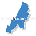
Maps


Graphs
Select a template below for downloading or customizing gragh for Voting District 020002, Sullivan County, New York


Neighbors
Neighoring Voting District (by Name) Neighboring Voting District on the Map
- Voting District 020001, Sullivan County, NY
- Voting District 020003, Sullivan County, NY
- Voting District 040001, Sullivan County, NY
- Voting District 070001, Sullivan County, NY
- Voting District 130003, Sullivan County, NY
Top 10 Neighboring County Subdivision (by Population) Neighboring County Subdivision on the Map
- Rockland town, Sullivan County, NY (3,775)
- Callicoon town, Sullivan County, NY (3,057)
- Delaware town, Sullivan County, NY (2,670)
- Fremont town, Sullivan County, NY (1,381)
Top 10 Neighboring Unified School District (by Population) Neighboring Unified School District on the Map
- Sullivan West Central School District, NY (10,576)
- Livingston Manor Central School District, NY (3,483)
- Roscoe Central School District, NY (2,086)
Top 10 Neighboring State Legislative District Lower Chamber (by Population) Neighboring State Legislative District Lower Chamber on the Map
Top 10 Neighboring State Legislative District Upper Chamber (by Population) Neighboring State Legislative District Upper Chamber on the Map
Top 10 Neighboring 111th Congressional District (by Population) Neighboring 111th Congressional District on the Map
Top 10 Neighboring Census Tract (by Population) Neighboring Census Tract on the Map
- Census Tract 9502, Sullivan County, NY (3,775)
- Census Tract 9504, Sullivan County, NY (3,057)
- Census Tract 9521, Sullivan County, NY (2,670)
- Census Tract 9503, Sullivan County, NY (1,381)
Top 10 Neighboring 5-Digit ZIP Code Tabulation Area (by Population) Neighboring 5-Digit ZIP Code Tabulation Area on the Map
- 12758, NY (4,042)
- 12776, NY (2,180)
- 12748, NY (2,076)
- 12723, NY (1,826)
- 12791, NY (737)
- 12766, NY (437)
- 12724, NY (245)
- 12745, NY (178)
- 12767, NY (126)